

Weather: El Niño’s Global Impact, US November Outlook
ANALYSIS - El Niño is expected to peak in December, according to the US' National Oceanic and Atmospheric Administration (NOAA).El Niño events are measured by the warmth of surface waters in a specific region of the equatorial Pacific compared to their long-term average. El Niño-related impacts have been occurring around the globe for months and will continue for several months after the warmest temperatures occur in the tropical Pacific Ocean.
Who’s Feeling the Effects of El Niño?
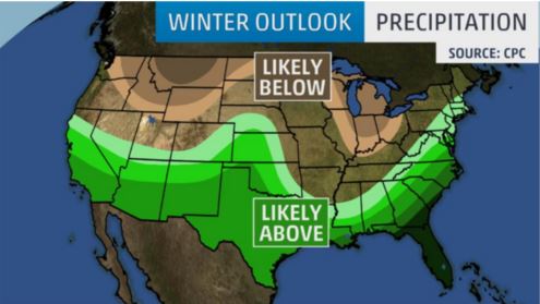
In the US, the season of strongest El Niño impacts is expected from December until March, and many are anxiously waiting to see what the strong 2015-16 El Niño will bring. The Weather Channel is predicting:
1. The South will be cooler than average, the North will be warmer.
2. The South will be wetter than average.

3. El Niño won't be the only player - the Arctic Oscillation, which influences the number of arctic air masses that penetrate into the South and nor'easters on the East Coast, and the Madden-Julian Oscillation, which can impact the number of heavy rain storms in the Pacific Northwest.
4. California could see some minor drought relief.
5. There's no way to know when or where it could get ugly.
“A strong El Niño is in place and should exert a strong influence over our weather this winter,” said Mike Halpert, deputy director, NOAA’s Climate Prediction Center.
“While temperature and precipitation impacts associated with El Niño are favoured, El Niño is not the only player. Cold-air outbreaks and snow storms will likely occur at times this winter. However, the frequency, number and intensity of these events cannot be predicted on a seasonal timescale.”
NOAA said around the globe, El Niño has had a substantial impact in two regions of Africa. According to the Climate Prediction Center’s International Desk, in East Africa, including Ethiopia, Somalia, Kenya, Tanzania, Uganda, Burundi, and Rwanda, the primary impact season is October–December, when El Niño tends to enhance the ”short rains” rainy season (the “long rains” season, which is much less ENSO-sensitive, is March-May), leading to wetter conditions. Over the last month, rain has begun to increase across much of the area, and some flooding has been seen in Somalia.
Short-term forecasts suggest the wetter conditions should continue through the next few weeks, at least. Southern Africa, including Zimbabwe, Botswana, Namibia, Angola, South Africa, Lesotho, Swaziland, and the southern half of Mozambique, tends to see a drier December–February during an El Niño. Areas of this region, especially South Africa, are very dry at the moment, after a failed monsoon last year. Another dry year would place more stress on water availability.
El Niño-related dry conditions in Indonesia have set the stage for devastating fires, and the region is experiencing the greatest number of forest fires since 1997. Also, all the extra warm waters associated with this El Niño are placing heat stress on sea life, and an intense coral bleaching event is underway.

“So far this year, there have been a total of 21 Category 4 and 5 storms in the North Pacific, shattering the old record of 17, set in 1997. The North Central Pacific region (140-180W) has shattered records for most named storms, hurricanes, and major hurricanes tracking through the 140-180W region,” said Phil Klotzbach with Colorado State University.
According to Lindsey Long of the Climate Prediction Center, the Atlantic season has been fairly quiet, although the number of named storms has been close to average, at 11 storms so far.
November Weather in the US
So far, November has been pretty mild across the central and eastern US. Temperatures have been well above normal for most of the nation with the exception of the far west and southwest where storms have kept temperatures cooler.
From the Great Plains all the way to the east coast, November has started off very mild with the warmest temperatures in the Great Lakes and Mid-Atlantic states. Out west, temperatures have been cooler than normal in Desert Southwest, California and portions of the Pacific Northwest. Along with those cooler temperatures there has been some much needed rain for many areas of central and northern California as well as portions of the Desert Southwest. Snowfall has been heavy so far in November over the central and northern Sierras and is expected to continue.
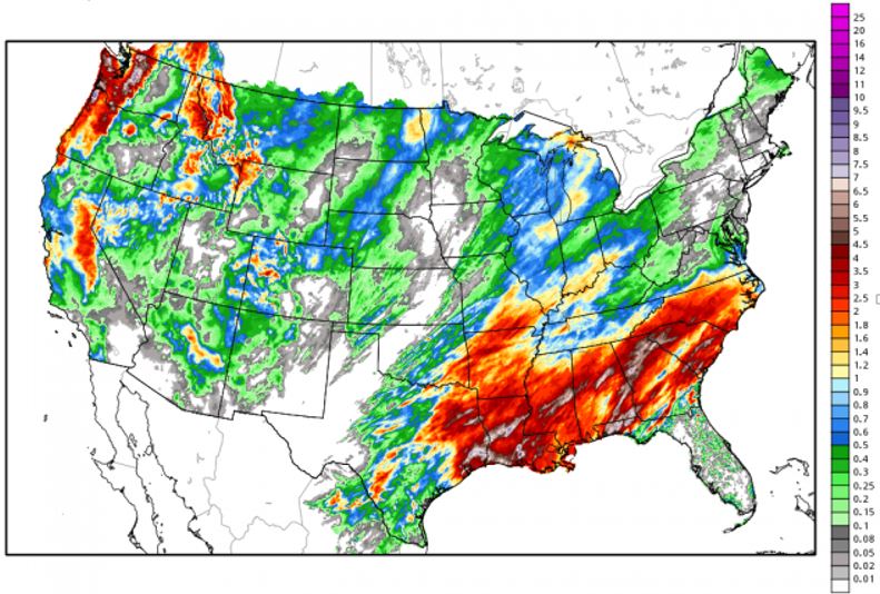
The graphic below highlights the precipitation that has fallen since November 1. As you can see the wet weather persists in the southeastern states with a nice swath of rain and mountain snows in the far west, especially the Pacific Northwest and California. Notice the heavy precipitation in the Sierras and the Cascades. Portions of the Colorado Rockies have picked up some nice early season snows.

All indications suggest that the trends experienced during the first ten days of November will continue into the next week to ten days. There will be more mountain snow and lower elevation rains across the western states and the western plains. There will be colder temperatures and some rain/snow in the upper Great Lakes later this week.
By the second half of November, the colder and wet weather in the west will expand eastward into the central and eastern areas of the US.
Therefore, despite the warm start for many stock growers in the central and eastern states, expect colder temperatures and better rain/snow chances during the last half of November, especially by Thanksgiving week and into early December.


